

About
MY BACKGROUND
Currently studying Geographic Information Systems at Appalachian State University. I am driven by curiosity and a passion for personal growth, I am a dedicated individual who thrives on the exhilarating journey of continuous learning. Seeking to become a highly effective team member within an organization where I can learn and grow my professional skills.
Education
WHAT I’VE LEARNED
Appalachian State University
Bachelor's degree, Geographic Information Systems
Aug 2020 - May 2025
Dean’s List Student - Member of club tennis at App State
Expected graduation May 2025
Experience
WHERE I’VE WORKED
Best Impressions, Caterer
May 2024 - Aug 2024
Lowes Hardware, Cashier
May 2023 - Aug 2023
Coursework:
• GIS Analysis and Modeling • Satellites, Drones, and Spatial Analysis • Web Mapping
• Introduction to Quantitative Methods • Environmental Remote Sensing
Skills & Abilities
• Certified Microsoft Office Specialist: Excel Associate
• Skilled in ArcGIS, Envi, and QGIS
• Experienced working with GeoJSON, LiDAR, and satellite imagery for analysis.
• Educated in basic programming language using RStudio, HTML, and JavaScript, with published
web maps on my GitHub Profile.
Remote Sensing
Remote sensing is the acquisition of information about an object or phenomenon without making physical contact with the object,
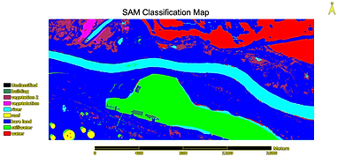
SAM Classification Map
This SAM Classification Map illustrates land cover categories derived using the Spectral Angle
Mapper (SAM) technique. The map classifies different surface types based on spectral similarity
to predefined endmembers. Key land cover types include water bodies (rivers, still water),
vegetation, buildings, roofs, and bare land.
ROI Points
ROI points in ENVI are used to mark specific areas in an image for analysis. They help with classification training, extracting spectral signatures, accuracy assessment, masking, and statistical analysis.


ROI Statistics
ROI statistics in ENVI provide data like mean, standard deviation, and pixel count for selected regions. These stats help compare classes, analyze spectral values, and support classification accuracy.
GIS
GIS (Geographic Information System) is a computer-based tool that captures, stores, analyzes, and displays spatial or geographic data. It helps visualize patterns, relationships, and trends in maps.


Average Interest Loan Grade Map
Shrimp Farm Suitibility
Bathymetric Cokriging Map
This map shows an average interest loan grade GWR (Geographically Weighted Regression) map of the US shows how average loan interest rates vary by location, with local regression results highlighting spatial patterns and influencing factors across different regions.
This map shows the suitability of different areas for shrimp farming, based on environmental factors like salinity, temperature, land use, and proximity to the coast, highlighting where conditions are most favorable.
This map shows bathymetric depths predicted using cokriging, a geostatistical method that combines depth measurements with related variables (like sonar or satellite data) to create a more accurate underwater terrain model.
Cartography
Cartography is the science and art of designing, producing, and studying maps. It involves representing spatial information visually to communicate geographic data clearly and effectively.

Heart Disease vs Income Map
This bivariate choropleth map shows the relationship between heart disease rates and income levels across regions. Each color represents a unique combination of both variables, helping to visualize where high or low income and high or low heart disease rates intersect geographically.

Imports of Crude Oil Map
This map shows the imports of crude oil by country, using color intensity to represent the volume of oil imported. It highlights major importers and reveals global patterns in crude oil demand and trade.

Dollar General Locations Map
This map shows the locations of Dollar General stores across the U.S., highlighting their widespread presence, especially in rural and low-income areas, and revealing patterns in retail accessibility and store distribution.
Arc Story Map
This ArcGIS StoryMap explores heart disease across the U.S., combining interactive maps, charts, and narrative text to highlight regional patterns, socioeconomic factors, and health disparities. It guides viewers through key insights about where heart disease rates are highest and how they relate to income, access to care, and lifestyle factors.
Web Mapping
This web map displays the locations of red light cameras throughout Chicago. Each point marks an intersection monitored for traffic violations, helping visualize where enforcement is concentrated and how it relates to traffic flow and safety across the city.